Description
....
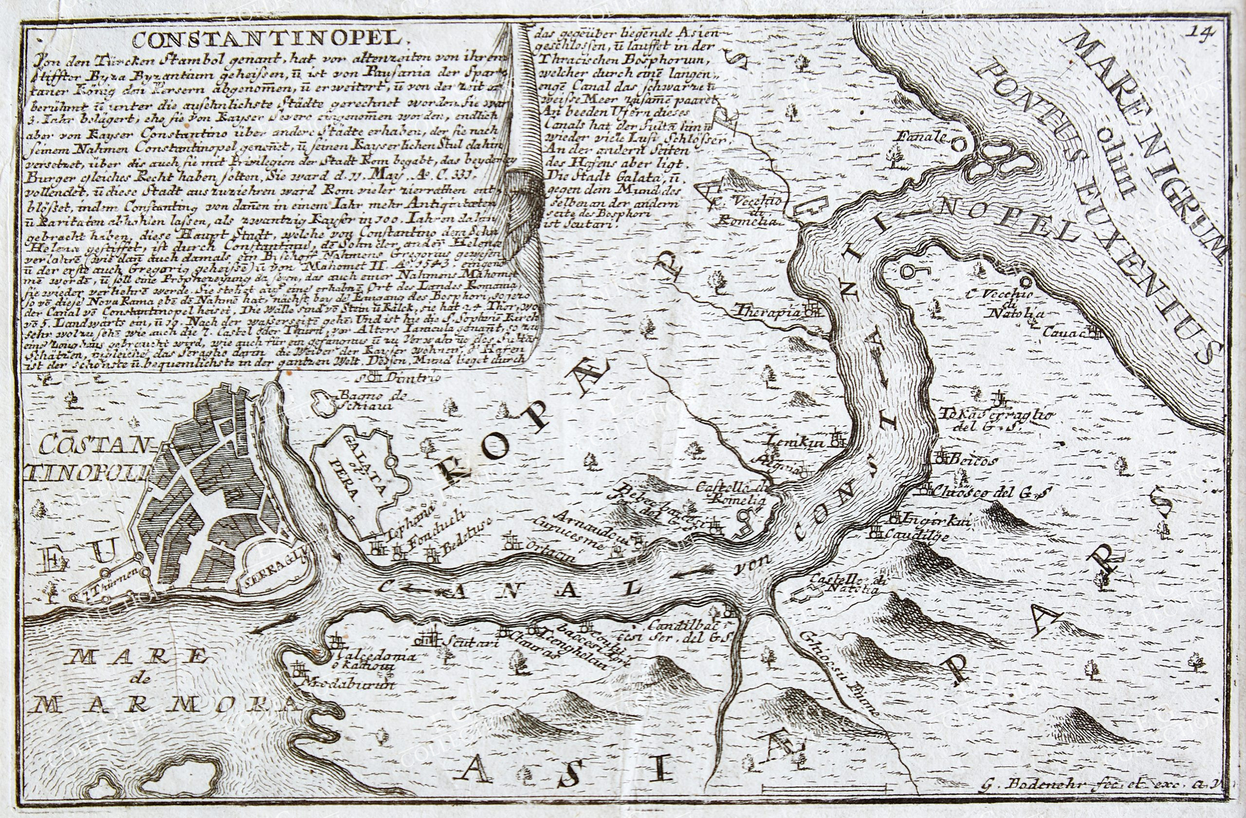
CONSTANTINOPEL
Gabriel BODENEHR
ca. 1700
19 x 30 cm.
The engraving is created by Gabriel Bodenehr the Elder, who is identified by the signature “G. Bodenehr fec. et exc. Aug. V.” on the bottom right corner of the map. Gabriel Bodenehr was a notable engraver and mapmaker from Augsburg, active during the late 17th and early 18th centuries. The specific date of this engraving is not directly mentioned on the map itself, but Gabriel Bodenehr’s works typically date from the late 1600s to the early 1700s.
This engraving is interesting for several reasons: 1. **Historical Context**: The map provides a historical depiction of Constantinople, a significant city that was a key point of intersection between Europe and Asia. It was also the capital of the Byzantine Empire and later the Ottoman Empire.
2. **Detail and Craftsmanship**: The engraving showcases intricate detail and high craftsmanship typical of Bodenehr’s work. Such maps were not only practical tools for navigation and planning but also works of art and status symbols.
3. **Cultural and Political Insight**: The map reflects the European perspective on the city during the time of its creation. The annotations provide valuable insights into how Europeans viewed Constantinople and its significance in global trade, politics, and culture.
4. **Geographical Information**: The map highlights important geographical features, such as the Bosphorus Strait (referred to as “Pontus Euxinus” leading to the “Mare Nigrum” or Black Sea) and the division between Europe and Asia, underscoring the strategic importance of the city.
5. **Educational Value**: For historians and scholars, such maps are critical primary sources for understanding the urban layout, infrastructure, and the socio-political environment of historical cities.
Overall, Bodenehr’s engraving of Constantinople is a fascinating piece for those interested in cartography, history, and the interplay between art and science in map-making. The text on the engraving provides a detailed description of Constantinople (modern-day Istanbul).
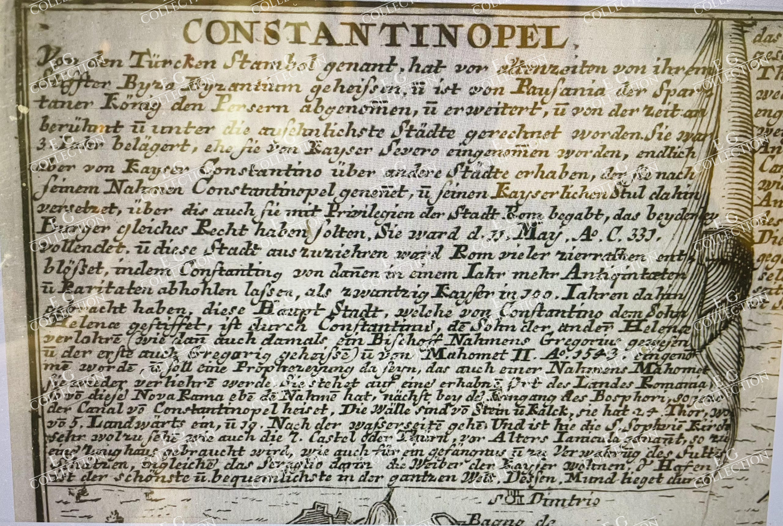
Below is a translation of the German text into English, capturing its essence:
“Constantinople The city known today as Istanbul, formerly Byzantium, was famously expanded by Emperor Constantine the Great, and hence named Constantinople. It is situated strategically on the Bosphorus Strait, connecting the Black Sea (Mare Nigrum) to the Sea of Marmara (Mare de Marmora). This geographical positioning has historically made the city a vital hub for trade between Europe and Asia. The city’s significance grew under Roman rule and later as the capital of the Byzantine Empire. It boasts numerous architectural marvels, including the Hagia Sophia, which served as a symbol of the city’s religious and cultural importance. During the Byzantine period, Constantinople was renowned for its fortifications, which protected it from numerous sieges. The Ottoman Turks conquered the city in 1453, transforming it into the heart of the Ottoman Empire. Under Ottoman rule, Constantinople flourished as a center of Islamic culture and learning, while also maintaining its status as a crucial commercial center. The city’s population is a mix of various cultures and religions, reflecting its cosmopolitan nature. Noteworthy is the Golden Horn, a natural harbor that has played a significant role in the city’s economic activities. The Bosphorus Strait remains a vital maritime route, further underscoring the city’s strategic importance. This engraving not only illustrates the physical layout of Constantinople but also highlights its historical and cultural significance, offering a glimpse into its rich past and enduring legacy.” This description provides historical context, emphasizing Constantinople’s transformation over the centuries, its architectural and cultural landmarks, and its strategic importance as a bridge between continents.
$ 2.800,00

 No products in the cart.