Description
....
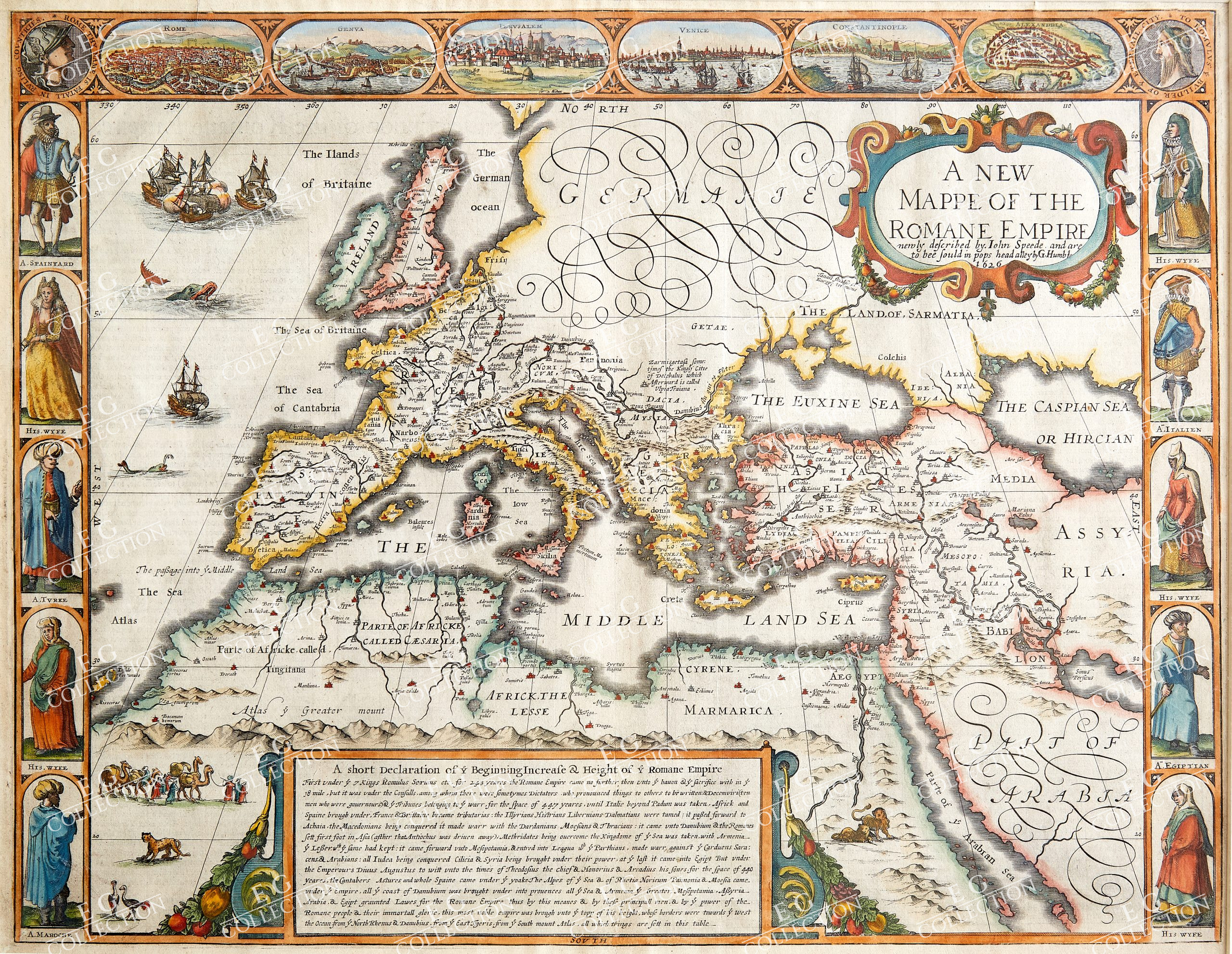
A NEW MAPPE OF THE ROMANE EMPIRE
SPEED, John
Published newly described by John Speed and are to be sold by Tho: Basett in Fleet Street & Ric: Chiswell in St.Pauls Churchyard. [1676]
39 x 50.5 cm.
A superb example of Speed’s carte-a-figure map of the Roman Empire at its height, from his ‘Prospect Of The Most Famous Parts Of The World.’ The map centres on the Mediterranean Sea, dividing Europe, North Africa, and Western Asia into their Roman era provinces, as well as depicting adjoining kingdoms and regions. The borders of the Roman provinces are outlined in hand colour, and feature anglicised versions of their original Latin names. Ancient cities and settlements are picked out in red, and sea coasts and mountain ranges are also highlighted in hand colour. The map is further embellished with a pair of lions in Nubia, an ostrich and leopard below a camel train in ancient Tingitania (Morocco), and a pair of sea monsters, a ship, and a naval battle in the Atlantic. In the top right corner, a strapwork cartouche encloses the title, while a larger box cartouche at the bottom of the plate contains a lengthy description of the history of the growth of the Roman empire.
Like other carte-a-figures maps, this example features three decorative borders. To the left and right, five pairs of male and female figures show the manner of dress of the various peoples that inhabit the former Roman empire. In seventeenth century habit are Spaniards, Italians, Tyrians, Egyptians, and Moroccans. In the top border are a set of six oval-bordered views of principal cities: Rome, Genoa, Jerusalem, Venice, Constantinople, and Alexandria, as well as a pair of portrait roundels in the form of Roman coins depicting the goddess Roma and the eponymous founder of the Empire, Romulus.
John Speed (1552-1629) is the most famous of all English cartographers primarily as a result of ‘The Theatre of the Empire of Great Britaine’, the first atlas of the British Isles. The maps from this atlas are the best known and most sought-after of all county maps. The maps were derived mainly from the earlier prototypes of Christopher Saxton and Robert Norden but with notable improvements including parish “Hundreds” and county boundaries, town plans and embellishments such as the coats of arms of local Earls, Dukes, and the Royal Household. The maps are famed for their borders consisting of local inhabitants in national costume and panoramic vignette views of major cities and towns. An added feature is that regular atlas copies have English text printed on the reverse, giving a charming description of life in the early seventeenth century of the region. The overall effect produced very decorative, attractive and informative maps.
Speed was born in 1552 at Farndon, Cheshire. Like his father before him he was a tailor by trade, but around 1582 he moved to London. During his spare time Speed pursued his interests of history and cartography and in 1595 his first map of Canaan was published in the “Biblical Times”. This raised his profile and he soon came to the attention of poet and dramatist Sir Fulke Greville a prominent figure in the court of Queen Elizabeth. Greville as Treasurer of the Royal Navy gave Speed an appointment in the Customs Service giving him a steady income and time to pursue cartography. Through his work he became a member of such learned societies as the Society of Antiquaries and associated with the likes of William Camden Robert Cotton and William Lambarde. He died in 1629 at the age of seventy-seven.
Condition: Strong impression with fine hand colour. Pressed central fold, as issued.
$ 4.500,00
1 in stock


 No products in the cart.