Description
....
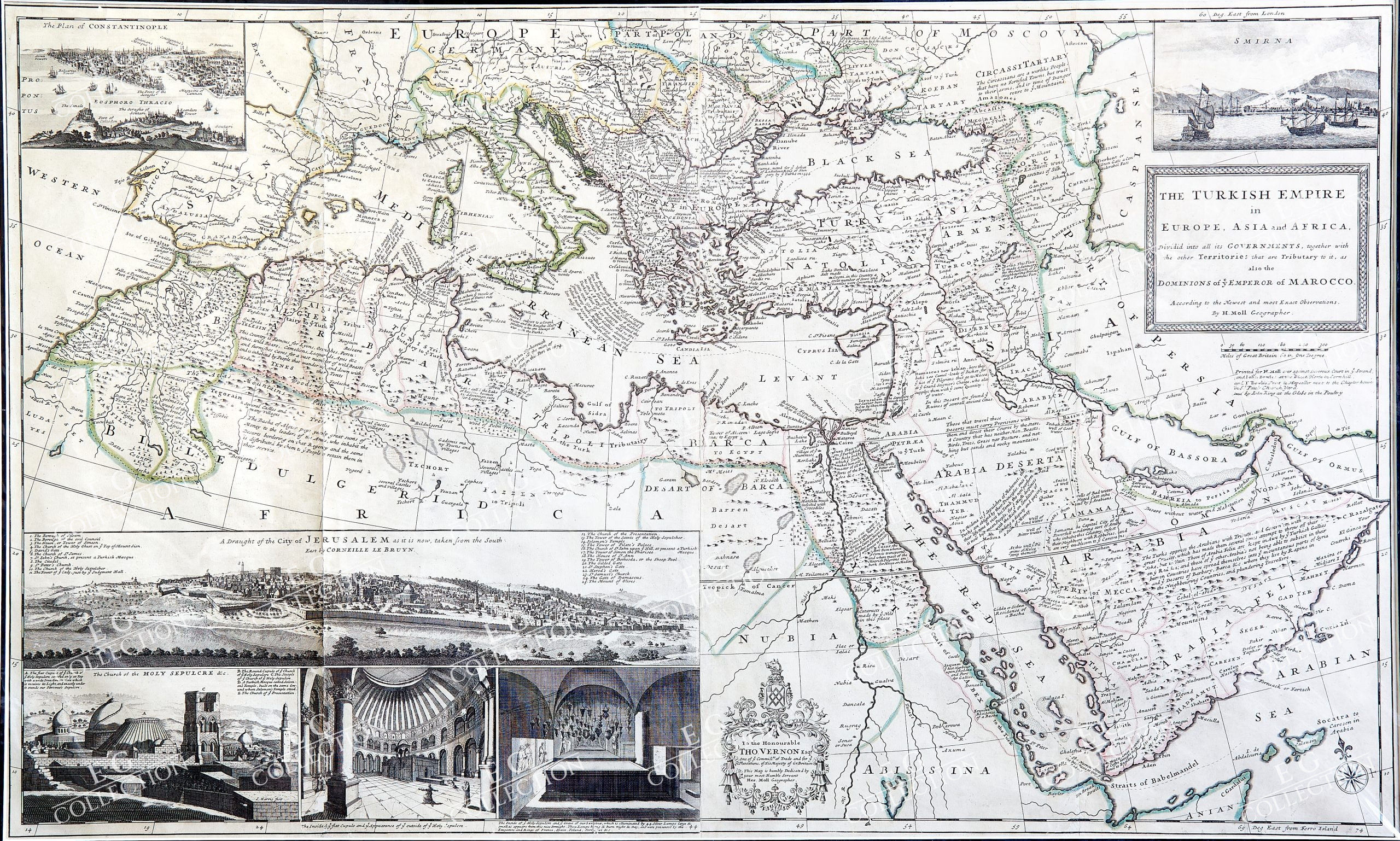
THE TURKISH EMPIRE IN EUROPE ASIA AND AFRICA DIVIDED INTO ITS GOVERNMENTS…
MOLL, Herman
London, c. 1730
100 x 60 cm.
Map of the Ottoman Empire with Rich Imagery of Jerusalem.
Striking large-format map of the Ottoman Empire by Herman Moll, one of England’s leading map makers at the beginning of the eighteenth century.
The map shows the sprawling Ottoman Empire, which stretched from Northern Africa to Greece to Anatolia to the Middle East. The limits of the empire are marked with a thick dashed line, while smaller polities are separated by thin dotted lines.
A major feature of the map are the detailed views of Jerusalem in the lower left corner. There is a bird’s-eye view of the entire city, credited to Corneille Le Bruyn. Cornelis de Bruijn was a Dutch artist and traveler. On his first great tour of the Eastern Mediterranean he visited Jerusalem and made clandestine drawings of the city. He published these in 1698, providing readers with some of the first updated glimpses of the city in decades. Additionally, there is a view of the Church of the Holy Sepulchre, one of the inside of the church’s cupola, and one inside the Holy Sepulchre itself. Additional insets include of Smirna and Constantinople.
Extensive notes are spread across the map, giving a sense of the people, landmarks, and geographic features in the area. For example, Malta is described as, “subject to a Grand Master and the Knights Hospitallers, who are always at war with the Turks.” In the interior of the Arabian Peninsula it says, “Those that travel these Deserts must carry Provisions with them and direct their Course by the stars. A Country that has neither Men, Beasts, Birds, Trees, Grass nor Pasture, and nothing but sands and rocky mountains.”
The title cartouche is a simple framed ornament. The dedicatory cartouche is more decorative, with the Vernon coat of arms, garlands, and flowers. The map is dedicated to Thomas Vernon (ca. 1670-1726), a Turkey Merchant and MP. Vernon worked for the Levant Company, which conducted British trade with the Ottoman Empire. Vernon briefly served as a Commissioner of the Board of Trade and Plantations in 1713-14, as mentioned here.
Based on the work of Guillaume de L’Isle, the map was first published in 1714. It was included in Moll’s atlas, The World Described, from 1715 onward.
Herman Moll (c. 1654-1732) was one of the most important London mapmakers in the first half of the eighteenth century. Moll was probably born in Bremen, Germany, around 1654. He moved to London to escape the Scanian Wars. His earliest work was as an engraver for Moses Pitt on the production of the English Atlas, a failed work which landed Pitt in debtor’s prison. Moll also engraved for Sir Jonas Moore, Grenville Collins, John Adair, and the Seller & Price firm. He published his first original maps in the early 1680s and had set up his own shop by the 1690s.
Moll’s work quickly helped him become a member of a group which congregated at Jonathan’s Coffee House at Number 20 Exchange Alley, Cornhill, where speculators met to trade stock. Moll’s circle included the scientist Robert Hooke, the archaeologist William Stuckley, the authors Jonathan Swift and Daniel Defoe, and the intellectually-gifted pirates William Dampier, Woodes Rogers and William Hacke. From these contacts, Moll gained a great deal of privileged information that was included in his maps.
Over the course of his career, he published dozens of geographies, atlases, and histories, not to mention numerous sheet maps. His most famous works are Atlas Geographus, a monthly magazine that ran from 1708 to 1717, and The World Described (1715-54). He also frequently made maps for books, including those of Dampier’s publications and Swift’s Gulliver’s Travels. Moll died in 1732. It is likely that his plates passed to another contemporary, Thomas Bowles, after this death.
$ 3.200,00
1 in stock

 No products in the cart.