Açıklama
....
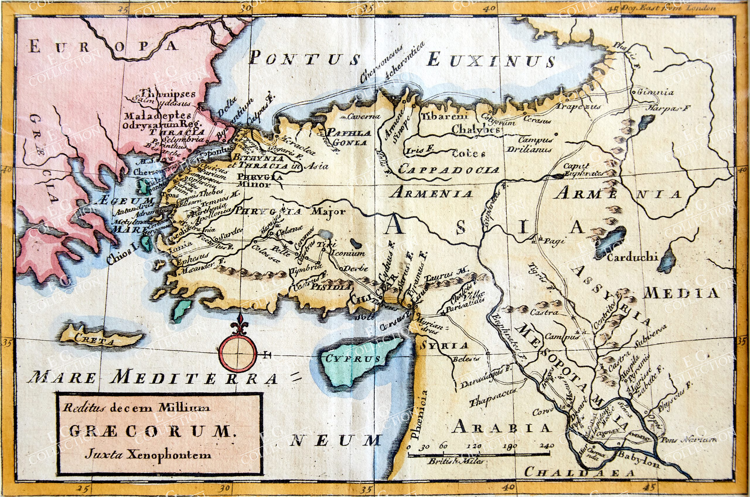
REDITUS DECEM MILLIUM GRAECORUM, iuxta Xenophontem MOLL, Herman
London, MDCCLXXXIV (1784)
15 x 22.5 cm
A map of ancient Greece and Asia Minor, from Bowles’ Geographia Classica, or the Geography of the Ancients, as contained in the Greek and Latin Classics. The map depicts the famous ‘March of the 10,000,’ as related by the Athenian soldier and historian Xenophon in his Anabasis. The coasts of modern-day Greece and Turkey are outlined in hand colour, as are mountain ranges, while the path of the Greeks on their journey is picked out in red. The Anabasis recounts the journey undertaken by a force of Greek mercenaries to join the armies of the Persian prince Cyrus the Younger in his unsuccessful bid to overthrow his brother, the Great King Artaxerxes II. Xenophon was himself a participant. When Cyrus was killed by a javelin during the Battle of Cunaxa, here labelled by Moll as ‘Connax,’ near Babylon in Mesopotamia, his Greek forces found themselves stranded in enemy territory and had to make their way past hostile tribes back to the Ionian coast and the safety of the Aegean Sea. As well as being a favourite of Medieval chroniclers, the Anabasis was also the inspiration for the cult novel ‘The Warriors’ and its 1979 film adaptation.
Bowles’ Geographia Classica, or the Geography of the Ancients, as contained in the Greek and Latin Classics was undertaken by Herman Moll as a supplement to the many eighteenth century editions of Greek and Latin classics published by Carington Bowles and his contemporaries. Most editions contained a total of 32 maps in an arrangement similar to Ortelius’ famous Parergon, depicting the kingdoms and provinces of the Greek and Roman world, elucidating particular texts such as ‘Caesar’s Gaul’ or the ‘Journeys of Aeneas,’ and including a number of biblical maps. Unlike the Parergon, which was accompanied by Ortelius’ copious notes and commentary, Moll’s Geographia Classica
contained no explanatory text, with the frontis instead explaining that the atlas was ‘Principally designed for the Use of Schools, as being accomodated for the more easy and clear Understanding of the Ancient Authors.’ The list as given by Moll included Homer, Herodotus, Justin, Virgil, Ovid, Florus, Nepos, Caesar, Livy, Lucan, and Plutarch.
Herman Moll (c.1654-1732) was born in Germany and came to England in the 1670s. He worked as an independent cartographer and geographer, and traded as a map publisher and seller for two years, and then worked for other publishers. Moll established his own business and eventually dominated the early eighteenth century map trade. He produced many maps and atlases of England, Wales, Scotland and Ireland. His county maps were all boldly engraved in a heavy style. Moll was also an active member in academic and intellectual circles, being a close associate of Daniel Defoe, Robert Boyle, Robert Hooke, and, most importantly for his cartographic career, the pre-eminent English explorer of the era, William Dampier.
$ 400,00
Stokta yok

 Sepetinizde ürün bulunmuyor.