Açıklama
....
Author:
(سودى)نك يكى خريطه كلياتندن [SÛDÎ’NIN YENI HARITA KÜLLIYATINDAN / SUDI’S NEW CARTOGRAPHIC ESTABLISHMENT].
Date:
1927
Short Title:
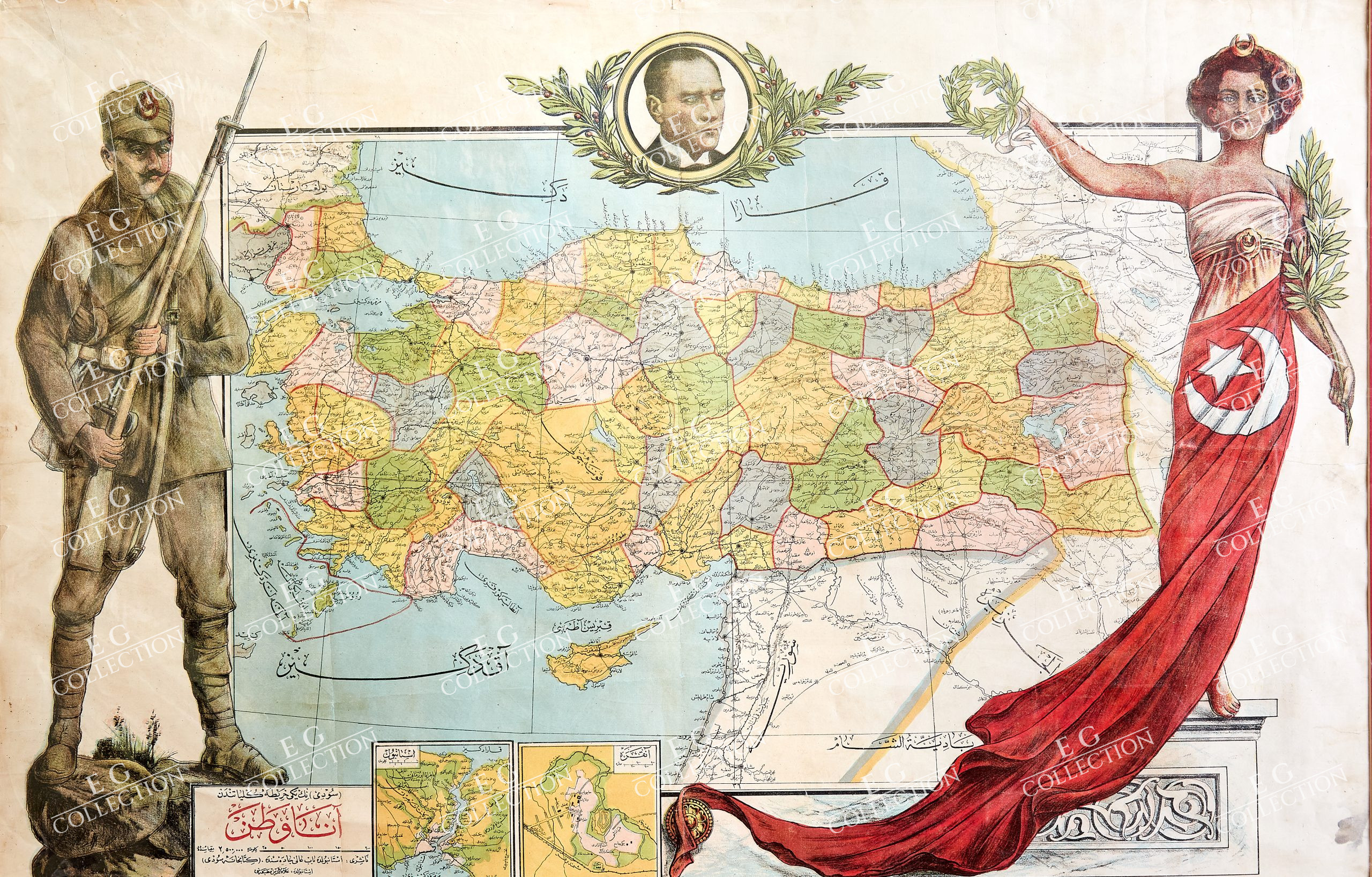
انا وطن [Ana Vatan / Homeland].
Publisher:
كتابحانه سودى [Kitaphane-yi Sûdî]
Publisher Location:
Istanbul
Obj Height cm:
67
Obj Width cm:
100
Publication Author:
(سودى)نك يكى خريطه كلياتندن [SÛDÎ’NIN YENI HARITA KÜLLIYATINDAN / SUDI’S NEW CARTOGRAPHIC ESTABLISHMENT].
Pub Date:
1927
Pub Title:
انا وطن [Ana Vatan / Homeland].
Note:
“‘Ana Vatan’ (Homeland) is one of the iconic images of Turkey’s Early Republican Era, being a colourful map of the country variously decorated with a portrait of its revolutionary founding president, Mustafa Kemal Atatürk; the figure of an infantry man, hailing the might and bravery of the Turkish Army which secured the nation’s independence; and the figure of a lady draped in the Turkish flag, personifying the virtue and liberty of the country – a large format ephemeral work – extremely rare. On October 29, 1923, Mustafa Kemal ‘Atatürk’ formally completed what virtually everyone a few years before would have considered impossible, by declaring the creation of the Republic of Turkey, a completely independent state embracing the great majority of the lands inhabited the Turkish people. The Treaty of Sèvres, (1920), which aimed to settle the fate of Anatolia and adjacent lands, in the wake of the collapse of the Ottoman Empire following World War I, inflicted the harshest possible terms on the Turkish people, denying them any chance to form a viable country. Istanbul and the Turkish Straits were to become an international zone controlled by the Great Entente powers; the Smyrna (Izmir) region of Western Anatolia was to become part of Greece; southwestern Anatolia was to be an Italian zone, Cilicia (southcentral Anatolia) was to be a French domain; while Eastern Anatolia was reserved for a proposed independent Armenian state. The Turks were to be left with a rump extending from central Anatolia to the Black Sea coast; the great majority of Turks were to live under foreign flags. Atatürk, a former Ottoman general and hero of the Battle of Gallipoli, and his associates never accepted the verdict of the Entente Powers. In 1919, he formed a nationalist movement that aimed to retake the Turkish lands by force, instigating a conflict known as the Turkish War of Independence (Türk Kurtuluş Savaşı, 1919-23). Headquartered in Ankara, then a small provincial city deep in the interior, Atatürk initially led a poorly equipped and under-funded rag-tag force of Ottoman veterans, in a situation not unlike Washington at Valley Forge. Indeed, Atatürk had to fight a multi-front war against at least six major opponents, although he benefitted from extremely low expectations, which caused their opposition to become exceedingly overconfident. Atatürk was a stellar proven battle commander and extraordinarily charismatic and bold leader, and against all odds he managed to galvanize his motley force into and amazingly driven and deadly war machine, that after teething pains, eventually came to vanquish all of their opponents on the battlefield, while causing their other foes to withdraw from the contest. By the latter part of 1922, Atatürk had decisively won the war, and the complete withdraw of all foreign powers from Anatolia, Istanbul, and Eastern Thrace (virtually all of modern Turkey) was assured. Atatürk would go on to found a revolutionary new Turkish state based upon his philosophy of Kemalism, summed up by what would become known as the ‘Six Arrows’ (Republicanism, Populism, Nationalism, Laicism, Statism, and Reformism). While controversial both in its time and up to the present day, Atatürk’s regime utterly transformed Turkey into a modern secular state more in line with Western European values than its Eastern roots. Turkey became a strong, confident regional power that was able to maintain its independence even in what was the world’s most dangerous d neighborhood. Anchoring Atatürk’s regime was one of the world’s world most sophisticated propaganda machines, that assumed great control over popular visual and literary culture. It was able to harness Turkey’s word-class communities of artists and authors to create posters, maps, paintings, books, pamphlets, and newspapers that celebrated Atatürk and his new revolutionary values. The present work is one of the most famous and beloved of all the propaganda works of the Early Republican Era. The present map was published by Sudi’s New Cartographic Establishment, a small, boutiquey Istanbul mapmaker. Little would they have known when they first released the map that it would become one of the most iconic and beloved images of Early Republican Turkey! Entitled ‘Ana Vatan’ (Homeland), the map is a veritable pageant of imagery, an unabashed celebration of the new Republic of Turkey and its founding principles. The centre of the composition is a conventional map the country, divided into brightly coloured provinces, and labelling all major cities, topographical features, railways and roads. Turkey’s boundaries are the same as they are today with the notable exception that the country did not then yet include the Hatay Province (featuring the cities of Antakya and Iskenderun), to the south, which is still shown to be a part of Syria; under Turkish pressure, Hatay would succeed from Syria in 1938, joining Turkey the following year later. To the lower left of the map are two cartographic insets, one showing Istanbul, the old Ottoman capital and Turkey’s commercial centre, and the other, Ankara, the new capital of the republic. At the top of the map is a portrait of President Atatürk, contained within a roundel, framed by laurels. To the left, is a large image of a Turkish infantry man in full field dress, honouring the very men who so valiantly, and against all odds, secured Turkey’s unity and independence. To the right, is an image of a woman, draped in the national flag, bearing laurels, and perched upon a Classical plinth; she personifies the new state, its virtue, liberty and hope for the future. The inclusion of the lady is iconographically significant in that it marks a dramatic rupture from Ottoman or Eastern patriotic imagery, for such figures had rather been a traditional part of Western culture (ex. the Roman goddess Libertas, Britannia, Marianne, Lady Liberty, etc.). Indeed, consistent Kemalist principles, the map is strictly secular, void of the Islamic iconography that was prevalent on Ottoman propagandist works. While the text of the map is entirely given in Ottoman Turks script (Turkey would shortly switch to using Latin script, in 1928-9), in line with Atatürk’s ethic, it features only the Western date of ‘1927’, as opposed to employing the old Ottoman Rumi calendar. ‘Ana Vatan’ struck a chord, and in its time and through the generations since, had been frequently reproduced and favourably commented upon in countless works. It was, and remains, one of the most popular and recognizable images of the early period of Atatürk’s regime, proving its success as a work of patriotic propaganda. The map would have been sold in bookstores and news kiosks to the general public, where it would have been hung in homes and offices. Despite the map’s contemporary popularity and the fact that it remains very well known, examples are today extremely rare. The ephemeral, fragile nature of the map would have ensured a very low survival rate. While we are anecdotally aware of a few examples of the map held by unspecified Turkish institutions, as well as in private collections, the only example we can trace outside of Turkey is held by the Library of Congress (acquired in 1928, perhaps as a diplomatic gift).” (Alexander Johnson, 2021)
$ 5.000,00
1 adet stokta


 Sepetinizde ürün bulunmuyor.