Description
....


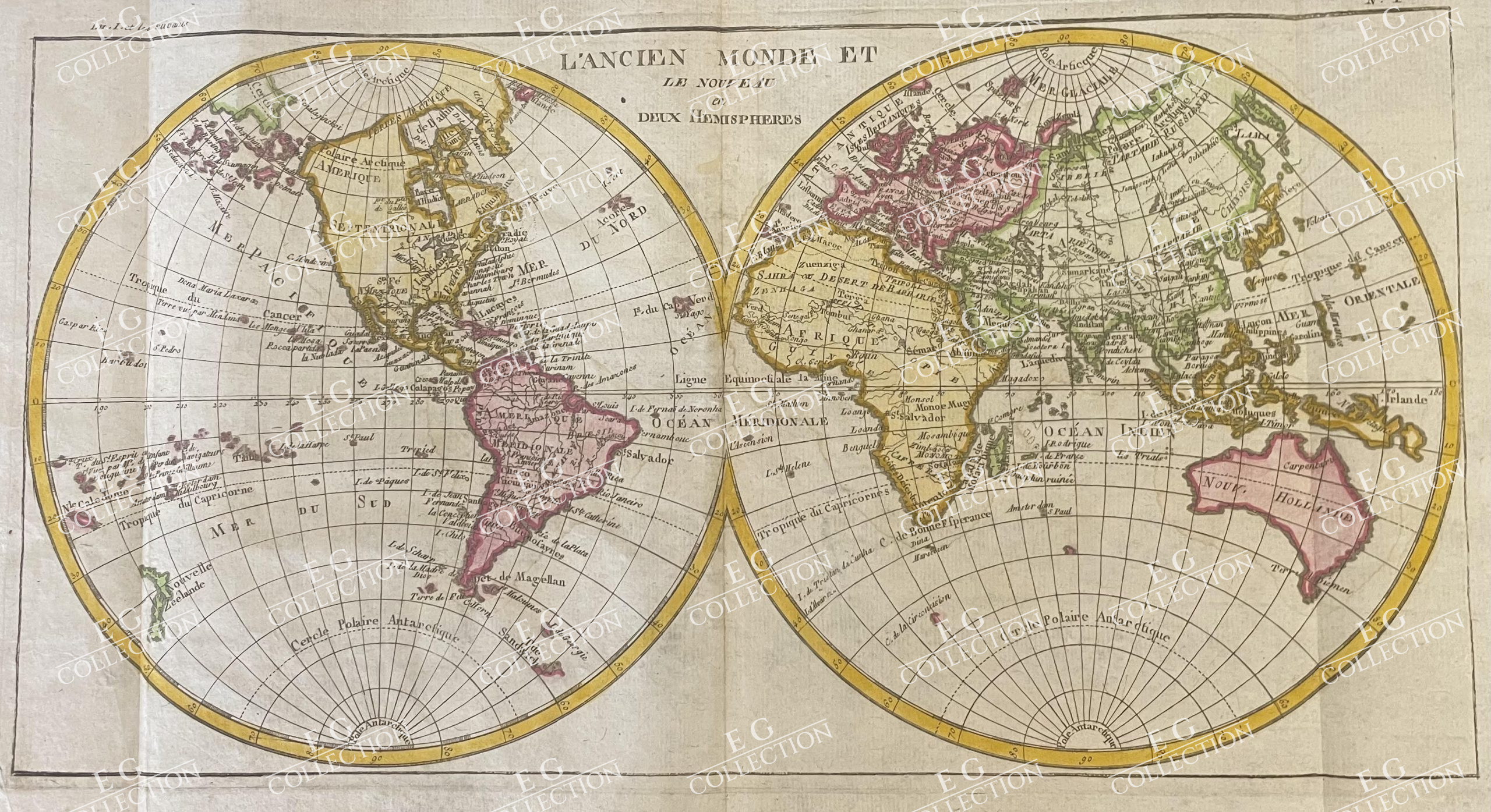
L’ANCIEN MONDE ET LE NOUVEAU en DEUX HEMISPHERES
Rigobert BONNE
1780
This image depicts a historical map titled “L’Ancien Monde et le Nouveau en deux Hemispheres,” created by Rigobert Bonne, a notable French cartographer, in 1780. The map is part of an atlas published by Jean-Leonard Pellet, and it measures 41 cm in width and 22 cm in height. This work is included in the atlas “Histoire Philosophique et Politique Des Establissements et Du Commerce Des Europeens Dans Les Deux Indes,” authored by Guillaume Thomas Raynal and Rigobert Bonne.
The map features two hemispheres, the Eastern and the Western, displaying the continents and various geographical regions of the world as understood in the late 18th century. The hemispheres are adorned with geographic labels and lines of latitude and longitude, illustrating the cartographic knowledge and style of the period.
Composition and Medium:
The map is uncolored originally, a typical feature of maps from this era, emphasizing clarity and detail over artistic embellishment. It is engraved, which was a common technique used for map production at the time, allowing for precise and detailed representation of geographic features.
Style and Subject Matter:
Bonne’s work is characterized by its scientific approach and meticulous attention to detail, reflective of Enlightenment ideals. The map captures both the “Ancient World,” including Europe, Asia, and Africa, and the “New World,” comprising the Americas and newly discovered territories in the Pacific.
Notable Features:
– Hemispheres: The map is divided into two circles, each representing a hemisphere. This format was popular for world maps during this period as it accommodated the curvature of the Earth.
– Geographic Landmarks: Prominent geographic features such as the “Mer du Nord” (North Sea), “Mer Pacifique” (Pacific Ocean), and “Mer du Sud” (South Sea) are clearly labeled.
– Lines of Latitude: The Equator, Tropics of Cancer and Capricorn, and the Arctic and Antarctic Circles are marked, aiding in navigation and geographic orientation.
– Inscriptions: The map is titled at the top center, with an inscription attributing the work to Bonne, who held the position of “Ingenieur-Hydrographe de la Marine,” signifying his role and expertise in marine cartography.
Cultural and Historical Context:
Created during the Enlightenment, this map reflects the period’s thirst for knowledge and exploration. It was a time when European powers were intensely interested in global exploration and expansion, driven by economic, scientific, and colonial motivations. The map was part of a broader intellectual effort to catalog and understand the world, aligning with the themes of Raynal’s philosophical and political history of European colonial establishments.
Significance:
This map is significant not only for its cartographic detail but also for its representation of contemporary geopolitical knowledge and attitudes. It illustrates the extent of European exploration and the perception of world geography at the time. The inclusion of both hemispheres underscores the global perspective that was emerging among European intellectuals and explorers.
This map is a valuable historical artifact, offering insights into 18th-century cartography, geography, and the cultural mindset of the Enlightenment. It serves as both a scientific document and a testament to the era’s quest for exploration and understanding of the world
$ 450,00

 No products in the cart.